


Here’s the latest wildfire update from the territory’s firefighters.
Richard Olsen, the territory’s fire operations manager with the Department of Environment and Natural Resources, gave his weekly briefing on Monday afternoon.
Olsen told us the 2015 wildfire season is already far, far busier than this time last year, and explained plans in place to protect firefighters against fatigue this summer – as well as giving details of specific fires being tackled right now.
Fire operations manager’s summary
Richard Olsen, fire operations manager, told us:
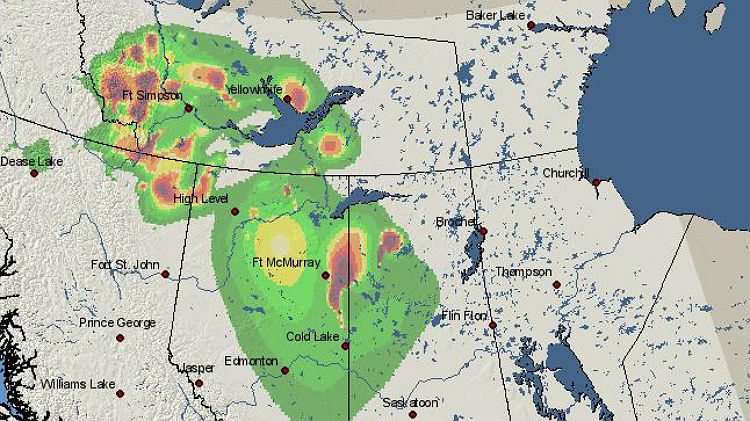
There have been 51 fires to date burning an area of just over 69,000 hectares. There are currently 38 fires still burning in the NWT. As a comparison to our average for this time of year, we’d usually expect seven fires this time of year and just over 5,000 hectares burned, so we’re well in advance of a normal year.
To date, six of the fires have been caused by holdovers from the 2014 fire season, seven fires were person caused, and the remainder are natural. All the person-caused fires are under investigation right now. It’s not a number that’s unusual for this time of year – our average for an entire season is 16, and late May and June is when we get the majority of our person-caused fires. Nothing we’ve heard so far indicates any purposely lit fires, other than an accident or the consequent of somebody not paying attention.
We have two sustained-action fires right now.
One is 50 km south of Behchoko, where crews undertook ignition operations on Friday. Those were successful and we’re following up with direct action along some of the southern portion. We suspect we’ll still be on that for another three or four days before we can walk away and monitor it.
The other fire is on Highway 1 between Kakisa and Fort Simpson, around 75 km east of Jean Marie River. It’s no threat to any community but it’s in an area with large fire growth potential under the conditions we’re experiencing. We’re limiting the fire’s growth and we’ll be on that for another four or five days.
Overall, no communities are at risk.
The week ahead
We did receive a little bit of rain over the last couple days, temperatures have dropped to slightly below seasonal right now, and our fire indices have levelled off quite a bit to the low and moderate level. For the most part, any fire of significance is going to continue to smolder away at this point in time, and any new starts are quite limited.
Some of that rain will really put a nice damper on the upper fuels. But in the long term, within three or four days, we’ll start to see some more fire activity. For anything to get into the deep, deep layers, we’d have to probably see an inch or two of rain.
We expect that by Wednesday or Thursday we’ll start to get into slightly above seasonal temperatures again, with a chance of rain and lightning. We’re looking at possible new fire starts somewhere toward the end of the week.
Fatigue a concern
We tried to give the majority of our resources last weekend off in order to try to address some issues with fatigue. We’re at the beginning of the fire season so we don’t want to be overworking people unless we have to, so they’re fairly fresh going into June.
All our crews are on right now, we’re just finishing off some final spring testing. We’ve got all our five long-term, intermediate helicopters in place and working, and an additional four short-term helicopters helping with fire operations; and we’ve got our four air tanker groups in place. With the chance of lightning and fresh starts this weekend, we might bring on additional resources as needed.
The biggest thing we did this year was to bring on resources early. We also accelerated our rotor-wing and air tanker groups, two weeks in advance of when we would normally start. We’re also undertaking some initiatives to keep track of potential gaps in resources, and have plans in place to cover people off when they need rest.
There’s a recognition from last year, and previous years, that the more you give a person a chance to rest their mind and body, allow them to recover and relieve that stress that comes with the position, the better they can come back and perform without risk to themselves or others.
We have brought in a fire behaviour specialist and a value protection specialist to help with assessment and planning, and how to mitigate the impact if there is a risk.
If you see a fire
If you do see fires, you can report them through our 1-877-NWTFIRE line. We’re also really trying to promote FireSmart initiatives with communities and cabin owners, in terms of mitigating risk from wildfires and things they can do.
Drought conditions
Frank Lepine, ENR associate director, told us:
We are under the effects of a very long-term drought. We are probably into year three or four of the drought if we look back at our numbers, affecting the North Slave, the South Slave and the Deh Cho regions. We tried to be ready earlier this year because of that.
Where it would normally take a day or two to put a fire out, in these conditions, it will take longer than that. For the fire crews on the ground, control is really difficult.
